Quantcast
Channel: Harxon – GPS World
Viewing all 71 articles
Browse latest View live

Harxon releases helix antenna series

$
0
0


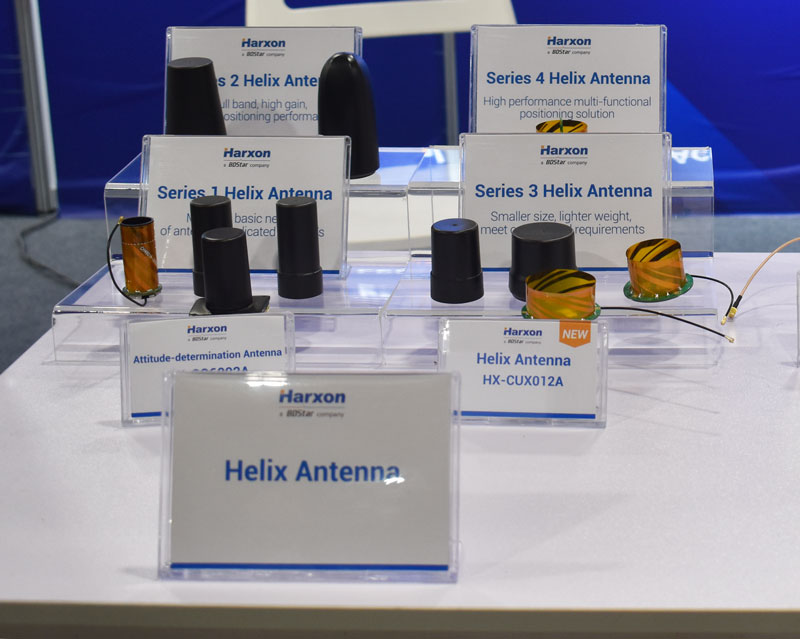
The HX-CUX012A, HX-CUX005A, HX-CH7609A and HX-CHX600A antennas at Harxon's XPONENTIAL 2023 booth.

The HX-CUX012A, HX-CUX005A, HX-CH7609A and HX-CHX600A antennas at Harxon’s XPONENTIAL 2023 booth.

Harxon has added to its helix antenna family with a series of four devices that are suitable for unmanned system applications.

HX-CUX012A is designed with extremely low profile, making it suitable for integration into UAVs, surveying and monitoring devices. It reduces the overall weight of applications, enables multipath mitigation and more.

HX-CUX005A is a solution for integrated helix antenna applications. It is designed with the integration of a GNSS antenna and Bluetooth/WiFi antenna, enabling communication and navigation without mutual interference.

HX-CH7609A is a low profile and small size housed helix antenna. It has comprehensive GNSS support including GPS, GLONASS, Galileo, BeiDou, as well as L-band correction services. HX-CH7609A features centimeter phase center repeatability and high gain at a low elevation. With signal filtering and multipath rejection, it provides reliable and stable GNSS signals.  

HX-CHX600A is a high-performance helix antenna that receives GPS, Galileo, BeiDou, GLONASS, as well as L-band signals. With 4.2 dBi high gain, it provides suitable tracking performance at a low elevation angle. Its low noise figure design reduces transmission interference and improves signal quality. 


XPONENTIAL 2023: Final thoughts

$
0
0

AUVSI XPONENTIAL 2023 has officially concluded. GPS World had the opportunity to visit several booths during the conference and attend a variety of educational sessions while in the heart of beautiful, downtown Denver.

See below for some takeaways from XPONENTIAL.

"Protecting the Homeland: The future of C-UAS” was presented by industry leaders and highlighted capabilities available for detecting, intercepting, and mitigating UAS encroaching or threatening covered facilities, critical infrastructure, and other high-value targets in the National Airspace System.

“Protecting the Homeland: The future of C-UAS” was presented by industry leaders and highlighted capabilities available for detecting, intercepting, and mitigating UAS encroaching or threatening covered facilities, critical infrastructure, and other high-value targets in the National Airspace System.

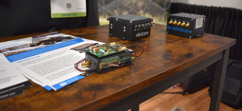
GPS World stopped by infiniDome to hear more about its solutions, including GPSdome.

GPS World stopped by infiniDome to hear more about its solutions, including GPSdome.

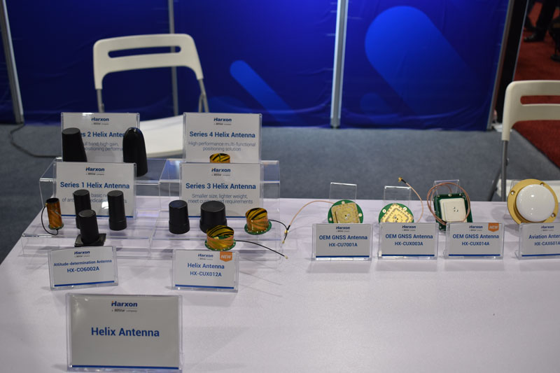
Harxon had its new helix antenna series on display at its XPONENTIAL booth.

Harxon had its new helix antenna series on display at its XPONENTIAL booth.

“Autonomous Exploration and Mapping of Unknown Environments with UAS” dove into the development of simultaneous localization and mapping, world modeling and exploration-based planning algorithms. This session was led by Eric Thorn, manager in the Intelligent Systems Division at Southwest Research Institute.

“Autonomous Exploration and Mapping of Unknown Environments with UAS” dove into the development of simultaneous localization and mapping, world modeling and exploration-based planning algorithms. This session was led by Eric Thorn, manager in the Intelligent Systems Division at Southwest Research Institute.

Honeywell shared the ground station that it is developing.

Honeywell shared the ground station that it is developing.

While CGConnect has already been launched overseas by Advanced Navigation, its first debut in the United States was at XPONENTIAL.

While CGConnect has already been launched overseas by Advanced Navigation, its first debut in the United States was at XPONENTIAL.

Harxon releases antennas for lawn mowers

$
0
0

Harxon has released two high-precision GNSS antennas suitable for robotic lawn mowers.

The HX-CSX014A is a high gain, low profile and compact antenna with a new structure that simplifies integration into lawn mowers and minimizes the overall machine dimension. It features small size, high sensitivity and low power consumption.

The HX-CSX231A, is a ready-to-use GNSS antenna with a highly reliable structure that makes it small and lightweight. It exhibits 4.5 dBi high gain performance with ultra-low signal loss. It also delivers wide beam width that covers wide frequencies with high marginal gain, a perfect option in complex environments.

Additionally, the HX-CSX231A’s advanced LNA features improved signal filtering, out-of-band rejection, restrained unwanted electromagnetic interferences and a strong multi-path reduction capacity.

To learn more about Harxon high precision GNSS solutions for lawn mowers, click here.

Image: Harxon

Image: Harxon

Image: Harxon

Image: Harxon

Launchpad: New antennas, scanners and survey applications

$
0
0

A roundup of recent products in the GNSS and inertial positioning industry from the May 2023 issue of GPS World magazine.


SURVEYING

OxTS Georeferencer 2.5

Survey Software
Georeference raw lidar data

Georeferencer 2.5 featuring anyNAV software is suitable for survey applications. Users of Georeferencer 2.5 with the anyNAV feature enabled can boresight payloads and georeference lidar data using the user’s navigation data. The anyNAV software enables lidar surveyors to create accurate point clouds quickly. Georeferencer 2.5 now takes navigation data from third-party inertial navigation systems, which enables users to use that data to georeference raw lidar data from multiple sensor families. The resulting data can then be viewed in many point cloud viewer software packages.
OxTS, oxts.com

Photo:

Inertial Navigation Solution
Designed to deliver accuracy in challenging environments

Ekinox Micro combines a high-performance MEMS tactical inertial sensor with a quad-constellation, dual-antenna GNSS receiver, making it suitable for mission-critical applications. The device includes pre-configured motion profiles for land, air and marine applications, enabling the sensor and algorithms to be tuned for maximum performance in any condition. The device is designed for ease of use and integration, with simple connectors, a web configuration interface, datalogger, Ethernet connectivity, a PTP server, a REST API for configuration, and multiple input and output formats. Ekinox Micro is compatible with real-time kinematic (RTK) solutions and based on a tactical 0.8°/h class inertial measurement unit calibrated across the entire operating temperature range. It features accuracy roll/pitch of 0.015°, accuracy heading of 0.035°, and accuracy position of 1.2 m without any corrections or 1 cm in RTK. The device also meets the MIL-STD-461, MIL-STD-1275, and MIL-STD-810 standards.
SBG Systems, sbg-systems.com

Image: Hexagon

Lidar Sensor
High-performance airborne bathymetric solution for deep water surveying

The HawkEye-5 increases survey efficiency by up to 25% compared to previous generations. The technology expands the capabilities of the Chiroptera-5 bathymetric lidar system, enhancing the productivity of applications such as nautical charting, environmental monitoring, and maritime surveillance in deep waters. The technology is designed to fit the Leica PAV100 gyro-stabilized mount, which isolates the sensor from unwanted aircraft movements — resulting in consistent data density and more efficient area coverage. The HawkEye-5 combined with the Chiroptera-5 features three lidar sensors, one four-band camera, and a QC camera to collect data from the seabed to land.
Leica Geosystems, leica-geosystems.com

Image: SingularXYZ

GNSS Receiver
Complete with network RTK rover

The Sfaira One GNSS receiver is small and centimeter accurate. It provides users with an entry-level network real time kinematic (RTK) rover. Sfaira One is equipped with a GNSS module with 1,408 channels for GPS, BDS, GLONASS, Galileo and QZSS tracking — providing centimeter positioning in harsh environments. It also features advanced RTK and an anti-interference algorithm. The GNSS receiver connects via Bluetooth and can be configured to conduct surveying tasks on a smartphone. Additionally, Sfaira One supports SingularPad and SingularSurv software and is also compatible with mainstream field survey or GIS software. Sfaira One is IP65 dustproof and waterproof, which makes the receiver suitable for all weather conditions. It has a 4,800 mAh battery life with 16 hours working time and type-C interface that can be charged on-the-go with a power bank.
SingularXYZ, singularxyz.com


MAPPING

Photo:

Mobile Mapping Solution
Built for large-scale infrastructure measurement and digital twin creation

The Pegasus TRK100 is small and light, making it easy to mount on any vehicle. The mobile mapping system features the same modular hardware approach that enables users to add more cameras to expand the range of use cases. With its advanced mapping capabilities, the Pegasus TRK100 enables GIS professionals to visualize and understand the location of assets to help make the right decisions, improve asset management, and support infrastructure building and maintenance. The Pegasus TRK100 combines artificial intelligence and a learning algorithm to enhance and optimize the clarity of points in post-processing for improved accuracy. The versatility of the Pegasus TRK100 suits a variety of applications in diverse industries, including telecommunications, utilities and road maintenance.
Leica Geosystems, leica-geosystems.com


OEM

Photo:

Photo:

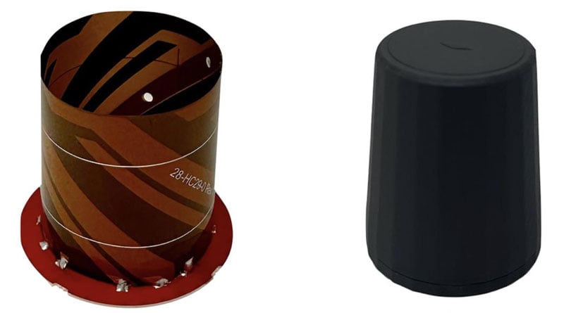
Helix Antenna Series
Suitable for unmanned system applications

HX-CUX012A is designed with an extremely low profile, making it suitable for integration into UAVs, surveying and monitoring devices. It reduces the overall weight of applications, enables multipath mitigation and more. HX-CUX005A is a solution for integrated helix antenna applications. It is designed with the integration of a GNSS antenna and Bluetooth/Wi-Fi antenna, enabling communication and navigation without mutual interference. HX-CH7609A is a low profile and small size housed helix antenna. It has comprehensive GNSS support including GPS, GLONASS, Galileo, BeiDou, as well as L-band correction services. HX-CH7609A features centimeter phase center repeatability and high gain at a low elevation. With signal filtering and multipath rejection, it provides reliable and stable GNSS signals. HX-CHX600A is a high-performance helix antenna that receives GPS, Galileo, BeiDou, GLONASS, as well as L-band signals. With 4.2 dBi high gain, it provides suitable tracking performance at a low elevation angle. Its low noise figure design reduces transmission interference and improves signal quality.
Harxon, en.harxon.com

Credit: Tallysman Wireless

Helical Antenna
Suitable for UAV applications

The HC990XF helical antenna is designed for precise positioning, covering the GPS/QZSS L1/L2/L5, QZSS L6, GLONASS G1/G2/G3, Galileo E1/E5a/E5b/E6, BeiDou B1/B2a/B2b/B3, and NavIC L5 frequency bands. This includes the satellite-based augmentation system (SBAS) available in the region of operation as well as L-band correction services. The HC990XF has a base diameter of 64 mm, is 37 mm tall and weighs 45 g. Its precision-tuned helical element provides full GNSS band coverage, suitable gain and axial ratio, and a tight phase center. The antenna base has an SMA (male) connector, three screw holes for secure attachment and an O-ring to waterproof the antenna connector. The HC990XF helical design does not require a ground plane, making it a suitable antenna for UAV applications.
Tallysman Wireless, tallysman.com

STMicroelectronics

Inertial Module
For automotive uses

The ASM330LHB automotive-qualified MEMS inertial-sensing module provides accurate measurements for a wide variety of vehicle functions. With the dedicated software provided, ASM330LHB also addresses functional-safety applications up to ASIL B1. ASM330LHB contains a 3-axis digital accelerometer and 3-axis digital gyroscope that provides a six-channel synchronized output. The module’s high-accuracy inertial measurements are used to improve the precise positioning of a vehicle. The accelerometer and gyroscope maintain high stability over time and temperature, and have very low noise for an overall bias instability of 3°/hour. Specified over the extended temperature range, -40°C to 105°C, the ASM330LHB has multiple operating modes that let designers optimize the data-update rate and power consumption.

ASM330LHB can support advanced driver assistance systems or vehicle-to-everything communication, as well as help stabilize sensing systems such as radar, lidar and visual cameras, and assist semi-automated driving applications up to L2+. Additionally, ASM330LHB can be used to enable a variety of functionalities in the body of a vehicle. ASM330LHB was developed with the automotive functional-safety standard ISO 26262 — the ASIL B compatible software library has been certified independently by TÜV SÜD. By implementing dedicated safety mechanisms, including data integrity and accuracy, the library ensures compliance with ASIL B automotive systems.

With the companion software engine, the ASM330LHB supports the growing adoption of automotive systems that require safety integrity up to level B. The combination of two ASM330LHB sensor modules for fail-safe redundancy delivers resilient contextual data for driver-assistance applications such as lane centering, emergency braking, cruise assistance and semi-automated driving. ASM330LHB is AEC-Q100 qualified and in production now in a 2.5 mm x 3.0 mm 14-lead VFLGA package.
STMicroelectronics, st.com

Credit: OxTS

INS
Built for automation applications

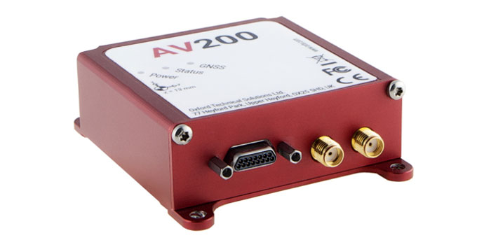
The AV200 is designed to give precise location data. It includes quad-constellation, dual-antenna, real-time kinematic (RTK) GNSS to provide users with position data as well as its temperature-calibrated, multi-core inertial measurement unit. These technologies give the AV200 position accuracy within 0.05 m, heading accuracy of 0.2°, and velocity accuracy of 0.2 km/h. The AV200 is built using the same technology that is commonly used for NCAP test validation, which has become the preferred technology for OEMs globally to test vehicles in both test-track and real-world scenarios.
OxTS, oxts.com

Credit: Inertial Labs

Reference System
For attitude and heading

AHRS-II-P is an enhanced, high-performance strapdown system that determines absolute orientation (heading, pitch and roll) for any mounted device. The AHRS-II-P can determine orientation for both motionless and dynamic applications. The AHRS-II-P contains a tactical-grade inertial measurement unit (IMU) consisting of three high-precision MEMS accelerometers, three advanced MEMS gyroscopes and a high-precision, gyro-compensated, embedded fluxgate compass. It also uses 8 mm fluxgate magnetometers. This device is suitable for a variety of devices such as UAVs, antennas, ships and robotic devices.
Inertial Labs, inertiallabs.com

GNSS Receiver
For accurate positioning and heading

As a high-precision integrated GNSS positioning and heading receiver, the A200 can track all existing and planned constellations — including GPS, BSD, GLONASS, Galileo, QZSS and SBAS — providing high-precision positioning and heading data for users. A200 is designed specifically for precision agriculture, machine control, fleet management, robot and other industries. The A200 is equipped with a K823 GNSS module. It also features 1,226 channels. The A200’s third generation IMU delivers fast initialization and ensures the output of heading during temporary GNSS signal loss. The built-in data link has low power consumption and a long working range. It also can be upgraded to a super-long-range data link module.
ComNav Technology, comnavtech.com

Launchpad: Laser scanners, rovers and PNT devices

$
0
0

A roundup of recent products in the GNSS and inertial positioning industry from the August 2023 issue of GPS World magazine.


SURVEYING & MAPPING

Laser Scanner
With several integration options

The VQ-840-G is a fully integrated compact airborne laser scanner designed for combined topographic and bathymetric airborne and UAV-based surveying. The system is offered with an optionally integrated and factory-calibrated inertial measurement unit/GNSS system and can be complemented with an optional camera or IR rangefinder. It also has an optional integrated inertial navigation system. The scanner carries out laser range measurements for high resolution surveying of underwater topography with a narrow, visible green laser beam, emitted from a pulsed laser source. The VQ-840-G has high spatial resolution due to a measurement rate of 200 kHz and high scanning speed of up to 100 scans/second.
Riegl, riegl.com

Photo:

Laser Scanning System
A versatile reality capture solution suitable for surveying, construction and engineering users

The X9 is designed to enhance performance in more environments while leveraging Trimble’s X-Drive technology for automatic instrument calibration, survey-grade self-leveling and laser pointer for georeferencing. The X9 expands on Trimble’s X7, delivering longer range, higher accuracy, shorter scan times and sensitivity, improving scan results. Advanced processing and a high-performance laser increase the sensitivity of all scans, enabling the X9 to capture difficult dark or reflective surfaces. A new center unit design also improves signal transmission for better scan quality. The X9 provides accurate and dependable data, enabling confident decision making both in the field and in the office through in-field registration with Trimble Perspective and FieldLink software by minimizing the need for target deployment. The auto-calibration eliminates the need for annual calibration. In addition, the X9 includes survey-grade self-leveling with the industry’s widest compensation range for fast, easy setup. The X9 data can be delivered directly from the Perspective or FieldLink software to Trimble’s office software — including the Realworks 3D scanning software — business center office software, SketchUp and Tekla, or exported to industry-standard formats to produce application-specific deliverables.
Trimble, trimble.com

C5 and C30. (Image: CHC Navigation)

Survey Cameras
For photogrammetric applications and to complement lidar survey data

The C5 and C30 orthographic and oblique cameras are designed for aerial surveys. The systems provide high-quality imaging solutions for photogrammetric applications and to complement lidar survey data. The C5 camera is an efficient and lightweight system for aerial surveys, weighing 290 g for increased flight endurance. Its compact size of 75 mm x 63.5 mm x 102.5 mm allows easy integration into UAVs. The C30 camera’s weight is 600 g with a size of 110mm x 108 mm x 85 mm. The C30 is also designed for aerial surveying. The C5 and C30 cameras’ universal installation design makes them compatible with a wide range of fixed-wing and rotor UAV platforms. Both cameras are supported by the CHCNAV’s BB4 Mini and P330 Pro UAVs as well as the DJI’s M300 RTK. The C5 and C30 cameras give maximum flexibility for photogrammetric applications. They can be used independently on real-time kinematic-enabled UAVs to capture high-resolution imagery or installed directly on the CHCNAV’s lidar series to colorize point cloud data. This feature allows seamless imagery and lidar data integration for a more complete view of the surveyed area.
CHC Navigation, chcnav.com

Image: ComNav Technology

GNSS Palm RTK
For surveying and mapping, GIS and more

The T20 is light, weighing 0.68 kg, and has low power consumption with 12 hours of battery life. It integrates functions such as a GNSS module, datalink module, 4G, 5.0 dual-mode Bluetooth, data memory system and more. Powered by the SinoGNSS K8 high precision module, the T20 has 1,590 channels and can track all running and planned constellations including GPS, BDS, GLONASS, Galileo, QZSS and satellite-based augmentation systems. Additionally, the anti-interference algorithm enables the T20 to maintain accurate positioning and perform well in complex environments, providing surveyors with high-quality measurements. The T20 is equipped with a third-generation inertial measurement unit from ComNav, which can be tilted and measured at an angle up to 60°. The T20 is also equipped with a U50 datalink module, which enables it to switch between base and rover. The T20 is compatible with mainstream real-time kinematic receivers on the market.
ComNav Technology, comnavtech.com

Image: Leica Geosystems

Hybrid Imaging and Lidar Sensor
Designed for airborne mapping

The CountryMapper is designed for large-area imaging and lidar mapping. Combining a large-format photogrammetric camera with a high-performance lidar unit into a single system, the CountryMapper collects foundational geospatial data simultaneously to support a wide variety of user applications. The CountryMapper combines imaging and lidar sensor modules into a highly efficient hybrid airborne system. The sensor features CMOS-based Leica MFC150 camera modules that leverage true mechanical forward-motion-compensation to deliver high image quality. The sensor’s new Hyperion3 lidar unit features 60° field of view, improving the performance and flexibility of the system compared to previous lidar modules, while reduced laser divergence provides greater planimetric accuracy and better foliage penetration. The CountryMapper fully integrates with Leica HxMap multi-sensor end-to-end processing workflow, enabling distributed processing of images and point clouds to optimize productivity for very large data sets. The CountryMapper supports applications such as orthophoto generation, terrain mapping, hydrography, forestry monitoring and infrastructure management. Users of previous-generation sensors can leverage their initial investment and upgrade their systems to the CountryMapper configuration.
Leica Geosystems, leica-geosystems.com


MOBILE

GNSS Network Rover
Complete with an integrated MEMS IMU

The Triumph-3NR (T3-NR) is a small, lightweight GNSS network rover with more than 25 hours of run time on a single charge. The T3-NR easily connects to real-time networks for corrections to get GNSS real-time kinematic with inertial measurement unit tilt compensation. The network rover has 874 channels and can track all constellations. It features an internal GNSS antenna, Wi-Fi, Bluetooth, and is USB compatible. The T3-NR is suitable for demanding industrial applications.
JAVAD, javad.com

Image: Harxon

Image: Harxon

Antennas
Suitable for lawn mowers and other mobile applications

The HX-CSX014A is a high gain, low profile and compact antenna with a new structure that simplifies integration into lawn mowers and minimizes the overall machine dimension. It features small size, high sensitivity and low power consumption. The HX-CSX231A, is a ready-to-use GNSS antenna with a highly reliable structure that makes it small and lightweight. It exhibits 4.5 dBi high gain performance with ultra-low signal loss. It also delivers wide beam width that covers wide frequencies with high marginal gain, a perfect option in complex environments. Additionally, the HX-CSX231A’s advanced LNA features improved signal filtering, out-of-band rejection, restrained unwanted electromagnetic interferences and a strong multi-path reduction capacity.
Harxon, en.harxon.com


DEFENSE

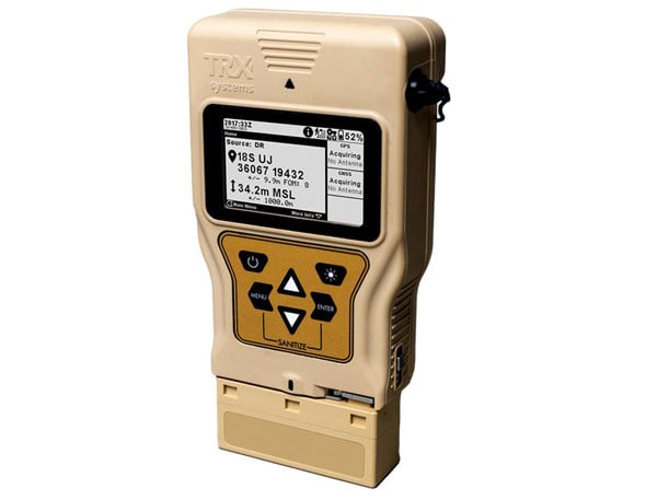
Image: TRX Systems 

PNT Device
Enables dismounted maneuver operations even where GPS is compromised or denied

The TRX DAPS II provides assured positioning, navigation, and timing (PNT) to dismounted users by disseminating assured position and time to dependent devices in GPS-challenged environments. TRX DAPS II fuses inputs from M-code GPS, inertial sensors, and complementary PNT sources. It is a small, lightweight PNT device that supports both standalone operation and integration with the Nett Warrior ensemble. It also can distribute PNT information to a customized tactical watch. The TRX DAPS II solution employs a modular architecture and adheres to Army PNT interface standards, facilitating the addition of new PNT sensors as threats evolve. This device will be in production for the Army later this year.
TRX Systems, trxsystems.com


TIMING

Image: Microchip Technology 

Image: Microchip Technology

Atomic Clock
Maintains system synchronization when GNSS signals are denied

The 5071B cesium atomic clock can perform autonomous time keeping for months in the event of GNSS denials. This device is the next-generation commercial cesium clock to the 5071A. The 5071B is available in a three-unit height, 19-in rackmount enclosure, providing a compact product to work in environments where it can be easily transported and secured versus a larger alternative designed specifically for laboratory environments. The 5071B has upgraded electronic components to address possible obsolescence or non-RoHS circuitry. The clock provides 100 ns holdover for more than two months, maintaining system synchronization when GNSS signals, such as GPS, are denied. As a cesium beam tube product with no deterministic long-term frequency drift, the 5071B provides absolute frequency accuracy of 5E-13 or 500 quadrillionths over all specified environmental conditions for the life of the product. For military applications requiring rapid deployments for system radars, 5E-13 stability eliminates the need for the acquisition of external synchronization sources prior to radiating.
Microchip Technology, microchip.com


OEM

NEO-F9P.png

GNSS Positioning Modules
For multiple applications

automation of moving industrial machinery, and the ZED-F9P-15B provides customers in the mobile robotics market with an L1/L5 option in addition to the L1/L2 bands. These two modules are based on the u-blox F9 high-precision GNSS platform. The NEO-F9P and the ZED-F9P-15B GNSS modules feature concurrent reception of GPS, Galileo, and BeiDou; multi-band L1/L5 real-time kinematic; short convergence times; and reliable performance. The modules deliver centimeter-level accuracy in seconds and come in small, high-precision form factors.

Its small size, coupled with very low power consumption and ANN-MB1 antenna compatibility, makes the NEO-F9P suitable for a wide range of uses. Offering reliable and efficient positioning, the module supports open as well as standards-based correction services for enhanced performance, such as the u-blox PointPerfect GNSS augmentation service.
u-blox, u-blox.com

Image: Septentrio

Image: Septentrio

GNSS Receiver Module
Features built-in AIM+ technology for interference mitigation

The mosaic-X5 is a multi-band, multi-constellation GNSS receiver in a low power surface mount module with a wide array of interfaces. It is designed for mass market applications such as robotics and autonomous systems — capable of tracking all GNSS constellations, supporting current and future signals. The mosaic-X5 has an update rate of 100 Hz, is easy to integrate, and is optimized for automated assembly. The mosaic-x5 is suitable for autonomous vehicles, logistics and port operations, mining and construction, precision agriculture, rail, robotics, surveying and mapping, UAVs and more.
Septentrio, spetentrio.com

The post Launchpad: Laser scanners, rovers and PNT devices first appeared on GPS World.

Harxon introduces GNSS solution for precision agriculture

$
0
0
Image: Harxon

Image: Harxon

Harxon has launched its TS122 family of smart antennas for demanding precision agriculture applications to increase GNSS availability, accuracy and reliability.

The smart antenna family is designed for high-performance semi-autonomous or autonomous applications that require centimeter-level accuracy – even in highly variable terrain and GNSS-obstructed environments. The TS122 family can be used for agriculture OEMs, integrators that develop precision agriculture solutions, autonomous solution providers and more.

There are two models for the new TS122 smart antenna: EUAA and EUUB. Each model has different performance options to fit users’ individual needs.

TS122 EUAA, with ±10cm P2P accuracy and standalone technology, is best for high-performance semi-autonomous or autonomous applications requiring centimeter-level accuracy, even in challenging GNSS-obstructed environments.

TS122 EUUB has single point 1.5 m circular error probable (CEP) and ±15cm P2P accuracy. Both models support RS-232 serial ports and Bluetooth communication for easy configuration of the smart antenna via users installing a configuration app on a phone or tablets, the company said.

The post Harxon introduces GNSS solution for precision agriculture first appeared on GPS World.

Harxon introduces new GNSS and helix antennas

$
0
0


Image: Harxon

Image: Harxon

Harxon has launched its new survey GNSS antenna, HX-CSX600A, and helix antenna, HX-CUX615A, designed for high-accuracy positioning applications across the geospatial industry. These two antennas are set to debut at INTERGEO 2023.

Survey GNSS antenna HX-CSX600A 

HX-CSX600A boasts a pre-filtered Low Noise Amplifier (LNA) offering exceptional out-of-band rejection, ensuring strong anti-interference performance even in challenging environments. It is designed for high-precision GNSS applications, including agricultural vehicles, small robots and surveying.

The new antenna offers reliable and consistent satellite signal tracking across a wide range of frequency bands, including GPS, GLONASS, Galileo, BeiDou, QZSS, IRNSS, SBAS, as well as L-Band correction services. With advanced multipoint feeding technology, HX-CSX600A maintains a stable phase center variation.

Built with an IP67-rated compact and ruggedized housing, this antenna is designed to withstand dust, rain, sunlight, shock and vibration. Its standard TNC-K connector and pole mount aims to simplify the integration process.

Helix antenna HX-CUX615A 

HX-CUX615A is the housed version of Harxon’s HX-CUX012A, designed for UAVs. Its low profile design and simple integration process makes this antenna ideal for various UAV applications such as aerial photography, remote sensing, infrastructure inspection, traffic control and public security.

Equipped with a pre-filtered LNA, HX-CUX615A offers out-of-band interference rejection to mitigate unwanted electromagnetic interference and provide reliable GNSS signals for seamless integration into positioning solutions.

This light-weight antenna also adopts patented D-QHA (Dual-Quadrifilar Helix Antenna) technology, ensuring stable wide-angle circular polarization (WACP) performance. This results in low-elevation satellite tracking, while maintaining high gain and reliable signal tracking – even in challenging environments.

The post Harxon introduces new GNSS and helix antennas first appeared on GPS World.

Launchpad: Mobile mapping, antennas and GNSS receivers

$
0
0

A roundup of recent products in the GNSS and inertial positioning industry from the October 2023 issue of GPS World magazine.


SURVEYING & MAPPING

GNSS Receiver
For GIS and survey professionals

The R2 GNSS system is a compact, durable, and flexible GNSS receiver that collects highly accurate data in a wide range of geospatial applications with submeter to centimeter positioning accuracy. The R2 can track the full range of GNSS satellite constellations and augmentation systems, and also comes with an integrated Trimble Maxwell 6 chip and 220 channels. Users can achieve higher accuracy in real-time with the ability to choose correction sources from traditional real-time kinematic, VRS networks, to Trimble RTX correction services delivered by both satellite and internet/cellular. The R2 can provide improvements to position availability and accuracy when heavy overhead cover, such as tree canopy and buildings, obstruct satellite signals. The receiver is also IP65-rated, making it suitable for rugged environments.
Trimble Geospatial, geospatial.trimble.comImage: Inertial Labs

Scanning and Mapping Solution
Designed for accuracy-focused remote sensing applications

The Resepi Teledyne Optech CL-360-HD has a powerful four-return laser and increased range of up to 750 m, making it ideal for mobile mapping, forestry and crack detection in critical infrastructure areas such as airport runways. Resepi is a sensor-fusion platform designed for accuracy-focused remote sensing applications. Resepi utilizes a high-performance INS and a high-accuracy dual antenna GNSS receiver, integrated with a Linux-based processing core and data-logging software. The platform also provides a Wi-Fi interface, optional imaging module, and external cellular modem for RTCM corrections. Resepi can be operated by a single hardware button or from a wirelessly connected device via a simple web interface. Resepi, equipped with Teledyne’s CL-360HD lidar, offers various laser scan speeds and frequencies, allowing users to tweak the settings to match their individual needs.
Inertial Labs, inertiallabs.com

Photo:

GNSS Receiver Series
Available in three different models for various applications

The Xtraordinary X1-series GNSS receivers include X1 and X1 Lite and X1 Pro. The X1-series adopts Linux OS, which improves the stability of the system and the synergistic compatibility of each module. This series of GNSS receivers features improvements to satellite tracking, the inertial measurement unit (IMU), battery life, and more. Optimized with a new generation of IMU module, users can easily initialize the IMU in 5-sec and start tilt measurements up to 60°. The X1-series GNSS receivers supports both 4G/radio correction data transmission and can reach up to 15 km range in enhanced internal UHF mode, 20 km range in external mode, and more than 50 km via internal GSM or PDA CORS mode.
SingularXYZ, singularxyz.com
Image: Hemisphere

GNSS Smart Antenna
For agricultural, marine, GIS, mapping and other applications

The A631 combines the Athena GNSS engine and Atlas L-band correction technologies with a new web user interface (WebUI). Optional features include 16 GB of internal storage, Bluetooth and Wi-Fi. The compact antenna is designed for rugged environments and meets IP67 requirements. With multiple operating modes, A631 can be used as an RTK base station or rover. The device is supported by the Atlas Portal, which empowers users to update firmware and enable functionality, including Atlas subscriptions for accuracies from meter to sub-decimeter levels. A631 also supports BaseLink and SmartLink modes. SmartLink allows users to directly connect AtlasLink as an extension to any existing system that has industry-standard connectivity options. BaseLink automatically sets up AtlasLink as a permanent reference station, delivering corrections to any other GNSS receiver being used for positioning.
Hemisphere GNSS, hemispheregnss.com

Photo:

GNSS Receiver
For land surveying, GIS, and construction applications

The Mars Pro combines GNSS, inertial measurement unit (IMU), and laser technologies. When set to laser mode, the Mars Pro can carry out measurements by selecting a signal-friendly spot within a 10-m radius, which aids in measuring hard-to-reach, signal-obstructed, and hazardous areas. With its millimeter-level laser distance meter integrated on its rear, the Mars Pro facilitates the utilization of the laser mode in scenarios involving surveying and stakeout. The integrated IMU sensor offers 60° tilt compensation, which remains functional even when operating in laser mode, allowing for uncompromised efficiency and accuracy. Equipped with the latest K8 platform, it boasts full-constellation support, offering 1,668 tracking channels and more than 60 satellite tracking capabilities across all existing and planned constellations — GPS, GLONASS, Galileo, BDS, QZSS and IRNSS. The Mars Pro offers support for precise point positioning (PPP) service, enabling rapid fixing within seconds. Its dynamic OLED color screen is sunlight readable and offers real-time visualization of essential data — satellite count, fixed state, on-off state, power, and more. It is compatible with mainstream brands and multiple protocols, such as Transparent, TT450S, SATEL, Trimtakl3, CHC and South.
ComNav Technology, comnavtech.com

Lidar System
For mobile mapping applications

The AlphaUni 20 lidar system (AU20) features advanced multi-target capabilities that support up to 16 target echoes for vegetation penetration. The AU20 captures ground surfaces with extreme precision, producing accurate digital elevation models and digital surface models in challenging environments. The lidar system has an accuracy of 2 cm to 5 cm. It has a lightweight, compact design that weighs 2.82 kg in its airborne configuration and a total of only 10.7 kg with its car mount kit, including a Ladybug5+. Its flexible multi-platform design allows users to install it on manned or unmanned aircraft for aerial scanning, integrate it into a variety of land vehicles, and even use it as a backpack-mounted system for mapping narrow areas.
CHC Navigation, chcnav.com

Image: Inertial Labs

Gyroscope
An advanced performance, tactical-grade MEMS gyroscope solution

Developed for use in particularly harsh environments, the TAG-304 gyroscopes can withstand extreme shock and vibrations in accordance with MIL-STD-810 standards. Additionally, TAG-304 gyroscopes are fully digitized (RS-422 interface), include built-in test (BIT) functionalities, and have no moving parts. TAG-304 is an advanced performance, tactical-grade MEMS gyroscope, of which size, power consumption, reliability and performance are ideal for accomplishing complex tasks requiring accurate stabilization of assorted platforms. Very low latency (group delay), small size, 4K Hz data rate, 1K Hz bandwidth, and low noise make TAG-304 gyroscopes a suitable solution for miniature electro-optical systems, gimbals, line-of-sight, and pan and tilt platforms stabilization and pointing applications.
Inertial Labs, inertiallabs.com

Image: ANELLO Photonics

IMU
For GNSS-challenged environments

The ANELLO IMU+ provides robust and reliable autonomous navigation and positioning in GNSS-denied or GNSS-compromised environments. Powered by optical gyroscope technology, the ANELLO IMU+ delivers high precision and reliability in demanding conditions, including shock, vibration, electromagnetic interference and temperature. The ANELLO IMU+ is suitable for autonomous applications in the construction, robotics, mining, trucking and defense industries.The device delivers long-term dead reckoning in high-temperature and high-vibration environments.The ANELLO IMU+ features unaided heading drift of < 0.5°/hr, dual high-speed CAN FD interfaces, and dual RS-232 interfaces; has ASIL-D ready, automotive-qualified CPU and OS; and is IP68 waterproof, resistant to dust, salt spray and chemicals.
ANELLO Photonics, anellophotonics.com

Image: Leica Geosystems

Flying Laser Scanner
Captures colorized 3D point clouds for producing 3D models, drawings, and visualizations

BLK2FLY is a fully integrated lidar UAV laser scanner with advanced obstacle avoidance for reality capture from the air. It can scan inaccessible areas such as rooftops, facades and large building interiors. BLK2FLY autonomously captures interior and exterior dimensions and features of buildings with a few taps on a tablet. Users can select an area within the map on their tablet and the BLK2FLY will create its own flight path to scan it quickly and safely. Users can send the BLK2FLY to scan a new area by tapping anywhere on the 3D view in the app. The BLK2FLY also can be piloted manually with virtual joysticks on a user’s tablet.

BLK2FLY can scan interiors of large arenas, stadiums, facilities, plants, and even obscured or confined outdoor areas with its Indoor Mode, which allows the BLK2FLY to get closer to objects with reduced flight speed and to fly within confined spaces without access to GNSS. With advanced obstacle avoidance and increased visual SLAM capabilities, the BLK2FLY’s Indoor Mode makes scanning inside fast and versatile.
Leica Geosystems, leica-geosystems.com


MOBILE

Image: Tallysman Wireless

Smart Antenna
Suitable for multiple applications

The HCS885XF/HCS885EXF smart helical GNSS antenna is suitable for UAV, land survey devices, automotive positioning, and other precise positioning/heading applications. The HCS885XF/HCS885EXF combines the performance and light weight of the Tallysman dual-band (GPS/QZSS L1/L5, GLONASS G1/G3, Galileo E1/E5a/b, BeiDou B1/B2/B2a) HC885SXF antenna with the low power consumption and GNSS augmentation capabilities of the u-blox NEO-F9P GNSS receiver. HCS885XF/HCS885EXF employs L5 signals (1160-1217 MHz), which transmit stronger signal power and a higher bandwidth chipping rate than L2 signals, thereby offering high performance when challenged with strong multipath signals. It also employs Tallysman’s eXtended Filtering system, which mitigates near-band and out-of-band interference, such as LTE signals and their harmonics and the planned Ligado service in North America, enabling operation in the most challenging deployments. The HCS885XF/HCS885EXF integrated receiver can simultaneously monitor four constellations, support base/rover RTK configurations (<1 cm), and use u-blox PointPerfect PPP-RTK augmented services over a terrestrial control network (3-6 cm). A moving-base precise heading configuration is available with base/rover antenna pairs.
Tallysman Wireless, tallysman.com

Image: Harxon

Antenna
Multi-constellation antenna for precision agriculture and semi-autonomous or autonomous applications

The TS122 EUAA provides centimeter-level accuracy in highly variable terrain and challenging GNSS-obstructed environments with ± 10 cm P2P accuracy and STANDALONE technology. The TS122 EUAA smart antenna receives dual-frequency multiple constellation signals from GPS, GLONASS, Galileo and BeiDou, with output position information up to 10 Hz. The antenna is capable of correcting deviations caused by a vehicle’s roll and pitch while working on uneven groups or slopes.
Harxon, harxon.com

The post Launchpad: Mobile mapping, antennas and GNSS receivers first appeared on GPS World.

INTERGEO 2023: Harxon Corporation

Launchpad: New antennas and UAV surveying software

$
0
0

A roundup of recent products in the GNSS and inertial positioning industry from the December 2023 issue of GPS World magazine.


SURVEYING AND MAPPING

Photo:

Survey Antenna
Designed for high-accuracy positioning applications

HX-CSX600A boasts a pre-filtered low noise amplifier (LNA) offering out-of-band rejection, ensuring strong anti-interference performance even in challenging environments. It is designed for high-precision GNSS applications, including agricultural vehicles, small robots and surveying. The antenna offers reliable and consistent satellite signal tracking across a wide range of frequency bands, including GPS, GLONASS, Galileo, BeiDou, QZSS, IRNSS, SBAS, as well as L-band correction services. With advanced multipoint feeding technology, HX-CSX600A maintains a stable phase center variation. Built with an IP67-rated compact and ruggedized housing, this antenna is designed to withstand dust, rain, sunlight, shock and vibration. Its standard TNC-K connector and pole mount aim to simplify the integration process.
Harxon, harxon.com

Image: SBG Systems

Image: SBG Systems

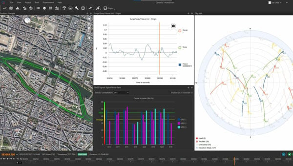
INS/GNSS Post-Processing Software
Designed for surveying applications

The Qinertia 4 introduces several features that provide users with a complete solution for precise trajectory and motion analysis. Qinertia is a post-processing software delivering better precision and reliability compared to real-time kinematic systems. It has an enhanced geodesy engine that boasts an extensive selection of preconfigured coordinate reference systems (CRS) and transformations, making it a versatile solution in applications that use diverse geodetic data, including land surveying, hydrography, airborne surveys, construction and more. To tackle the challenges of variable ionospheric activity, the technology uses Ionoshield PPK mode. This feature compensates for ionospheric conditions and baseline distances, allowing users to perform post-processing kinematics (PPK) even for long baselines or harsh ionospheric conditions. Another addition to Qinertia 4 is extended continuously operating reference stations (CORS) network support. This feature offers users a vast network of 5,000 SmartNet stations for reliable GNSS data processing.
Qinertia has more than 10,000 bases in 164 countries. This global coverage ensures Qinertia remains a reliable and efficient solution, regardless of geographic location. In addition, users can import their own base station data and verify its position integrity with precise point positioning (PPP). For data that cannot be processed using PPK, Qinertia 4 offers an alternative solution with its new tightly-coupled PPP algorithm. This new processing mode, available for all users with active Qinertia maintenance, provides post-processing anywhere in the world without a base station, with a horizontal accuracy of 4cm and a vertical accuracy of 8cm.
SBG Systems, sbg-systems.com

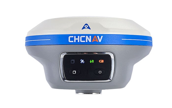
Image: CHCNAV

IMU-RTK GNSS Receiver
A compact, high-performance receiver with high-end dual camera technology

The i89 visual inertial measurement unit (IMU) GNSS receiver is a surveying device equipped with a 1,408-channel GNSS module that enhances real-time kinematic (RTK) availability, even in challenging environments. Its iStar 2.0 software incorporates advanced ionospheric modeling algorithms, achieving a high integrity RTK fix rate, particularly critical in regions of intense solar activity. The implementation of AUTO-IMU technology eliminates the need for manual initialization, streamlining field operations for increased efficiency. The i89 offers 16.5 hours of battery life and a lightweight 750 g design. The combination of panoramic capture mode and integrated IMU significantly improves the accuracy and efficiency of photogrammetric surveys.
CHC Navigation, chcnav.com

FJD Trion V10i GNSS system with visual positioning. (Image: FJDynamics)

GNSS System
Features visual positioning capabilities

The Trion V10i GNSS System integrates two cameras for vision-guided surveying operations, an inertial measurement unit (IMU) for tilt surveys and an OLED screen for easy status checks. This device is designed to enhance productivity in the field, even in hard-to-access locations. It features IMU-based tilt compensation for precise measurements of up to 60° with no calibration needed. It also comes with a built-in 4G LTE and UHF and supports NFC, Wi-Fi and Bluetooth. It also offers users seamless connectivity through Trion Survey Cloud for real-time data sharing between field and office teams.
FJDynamics, fjdynamics.com

Image: Exail

INS
For mobile mapping applications

The Atlans 3 is an inertial navigation system (INS) designed for land and air mobile mapping applications. The device is an all-in-one positioning and orientation system integrating unique micro-electro-mechanical systems. MEMS-FOG hybrid technology and a dual-antenna real-time kinematic GNSS receiver are housed within one compact device. The Atlans 3 offers north-keeping capability at FOG-level performance across a variety of land and air mobile mapping applications. It delivers real-time heading, even in GNSS-challenging environments such as urban canyons, mountainous terrain, or forested areas. The lightweight INS is designed to meet the requirements of high-performance lidars mounted on vehicles where space and weight constraints are critical. The Atlans 3 is designed to be quick and simple to install on all platforms. It offers efficient “set-and-forget” operations for a wide range of land and air applications including road and rail asset inventory, pavement condition survey, vehicle automation, HD mapping, ground-truth, airborne surveys and precision pointing.
Exail, exail.com

Image: Tallysman

L-Band GNSS Antennas
Available in four models

The ARM972XF triple-band plus L-band GNSS antennas provide GPS/QZSS L1/L2/L5, GLONASS-G1/G2/G3, Galileo E1/E5a/E5b, and BeiDou B1/B2a/B2b + L-band coverage. The technology is designed for precision triple-frequency positioning where light weight and a low profile are required. The ARM972XF are small and lightweight housed triple-band precision mini ARINC GNSS antennas. They have an average phase center variation of less than 10 mm for all frequencies and overall azimuths and elevation angles. Additionally, both models are available with components qualified for low-Earth orbit (LEO). Housed in a weatherproof (IP67) enclosure, the ARM972XF is available in four versions. Model ARM972XF-1 (ARM972XF-1-S for LEO space-qualified components) has an integrated 100 mm ground plane, while model ARM972XF-2 (ARM972XF-2-S for LEO space-qualified components) is 83 mm in diameter. The antennas also include Tallysman’s eXtended filtering (XF) technology, designed to mitigate GNSS interference.
Tallysman Wireless, tallysman.com


UAV

Photo:

Helix Antenna
Designed for UAVs

The HX-CUX615A has a low-profile design and simple integration process that makes it a suitable antenna for various UAV applications such as aerial photography, remote sensing, infrastructure inspection, traffic control and public security. Equipped with a pre-filtered LNA, HX-CUX615A offers out-of-band interference rejection to mitigate unwanted electromagnetic interference and provide reliable GNSS signals for seamless integration into positioning solutions. This lightweight antenna also adopts patented dual-quadrifilar helix antenna technology, ensuring stable wide-angle circular polarization performance. This results in low-elevation satellite tracking, while maintaining high gain and reliable signal tracking — even in challenging environments.
Harxon, harxon.com

Photo:

VToL UAV
A fully autonomous fixed-wing VTOL UAV with multiple power configurations and a heavier payload

The E455 is a fixed wing, vertical takeoff and landing (VTOL) UAV. At 55lbs, the E455 offers a 2-hour flight endurance operating on battery power alone. It is designed to carry a variety of payloads, including mapping sensors, lidar and EO/IR surveillance sensors. Where allowed, the E455 can fly at gross weights up to 65 lbs, which offers users more versatility in payload selection. The E455 also features an open control payload bay, which allows for the seamless integration of custom payloads.
EVENT 38, event38.com

Image: Virtual Surveyor

UAV Surveying Software
With added UAV photogrammetry capabilities

The Terrain Creator app photogrammetrically processes UAV images to generate survey-grade terrains that then transfer into the traditional Virtual Surveyor workspace. Terrain Creator aims to simplify the aerial photogrammetry process by offering a visual and intuitive application to produce an orthomosaic and a digital surface model (DSM) from UAV photos, the company said. The software was originally developed to bridge the gap between UAV photogrammetric processing applications and engineering design packages. Prior to this new release, users had to rely on third-party software to generate elevation models and an orthomosaic on which they could work with the Virtual Surveyor toolset. Now, users can derive the 3D topographic information necessary for construction, surface mining and excavation projects in one package. Once the survey-grade terrains flow from the Terrain Creator into the Virtual Surveyor desktop app, users can access an interactive virtual environment and robust toolsets to generate CAD models, create cut-and-fill maps and calculations, or calculate volume reports. Users currently subscribed to Virtual Surveyor Ridge and Peak editions will see their software updated automatically with Terrain Creator. A flexible licensing setup will allow two users within a subscribing organization to use the Terrain Creator and Virtual Surveyor applications simultaneously from different computers.
Virtual Surveyor, virtual-surveyor.com


MOBILE

Photo:

Antenna
Designed for high-precision and autonomous multi-frequency applications

The M10HCT-TNC GNSS L1/L2/L5 antenna is ground-plane independent and offers extremely low power consumption and minimal phase-center variation over azimuth crafted for GNSS high-precision applications. The antenna offers suitable axial ratio, ensuring multipath error is mitigated. Several filtering groups allow this antenna to have superb filtering capabilities and RF antijamming mitigation capabilities.
Maxtena, maxtena.com

Image: ComNav Technology

GNSS Receiver
Suitable for personnel positioning, IoT, railway patrols, vehicle tracking, and search and rescue missions

Equipped with the SinoGNSS K8 platform, the Z30 can track full constellations and multiple frequencies, providing centimeter-level accuracy. With 965 channels, it is capable of tracking more than 60 GPS, BeiDou, GLONASS, Galileo, QZSS, IRNSS and SBAS satellites. The Z30 features an integrated antenna for stable signal reception. The device is also equipped with two side buttons for power, one-click SOS alerts and three Indicator LEDs for power, satellite, and differential status checks. It supports NTRIP and TCP protocols, enabling various personnel positioning applications by uploading position data. The Z30 integrates with NaviCloud, offering functions such as real time location display, historical trajectory query, remote control, and electric fence. In addition, it can be customized to meet specific customer requirements. With indoor and outdoor positioning capabilities, the Z30 is a suitable solution for various fields. It supports outdoor real-time kinematic positioning with centimeter-level accuracy and indoor Bluetooth positioning with sub-meter-level accuracy.
ComNav Technology, comnavtech.com

Image: Pasternack

Antennas
IoT multiband antennas designed for multiple mobile applications

The Pasternack IoT multiband combination antennas are designed for vehicles, fleets and pivotal base stations. The technology aims to revolutionize how industries perceive and use mobile connectivity. The antennas integrate 4G, 5G, Wi-Fi and GPS bands to offer emergency teams, on-the-move fleets and first responders an unwavering link, even in harsh environments. Facilitated with both FAKRA and SMA connectors and extended 17-foot cable leads, users can seamlessly integrate the technology. It also has an IP69K rating, certifying it for both indoor and outdoor deployments. MIMO capabilities improve data transmission speeds and reliability, ensuring consistent high-bandwidth connections. The antenna’s GPS/GNSS component, enhanced with LNA and amplified by a 26 dB gain, offers users improved navigation and tracking precision.
Pasternack, pasternack.com

The post Launchpad: New antennas and UAV surveying software first appeared on GPS World.

Harxon expands line of smart antennas for precise positioning

$
0
0

Smart antenna series

Harxon has introduced a new line of smart antennas that seamlessly integrate advanced antenna technology with a comprehensive real-time kinematic (RTK) positioning module. These products offer high-precision positioning capabilities within a compact and easily integrable form factor, making them ideal for various applications.

The smart antennas incorporate full-constellation, full-frequency RTK positioning modules, enabling a range of accuracy levels to suit different needs. Users can achieve single-point meter-level accuracy, DGPS sub-meter-level accuracy or RTK centimeter/millimeter-level accuracy depending on their requirements.

The series includes both housed and embedded versions tailored for specific use cases. The HX-MR401A and HX-MR402A are housed versions, while the HX-ME403A and HX-ME404A are embedded versions designed for UAVs. These models leverage Harxon’s low-profile helix antenna technology. For robotic lawnmowers, Harxon offers the HX-ME401A and HX-ME402A, which are based on the cost-effective and high-performance OEM GNSS Antenna HX-CSX231A26.

Photo:
Photo: Harxon

OEM GNSS antenna

Harxon has expanded its OEM GNSS antenna lineup with two combined antennas: the HX-SE402A and HX-SE403A. These full-band, full-frequency antennas integrate GNSS capabilities with a low-profile radio antenna that supports the 858-878MHz and 902-928MHz frequency bands. This addresses the growing need for devices requiring both navigation and communication functionalities.

Unlike traditional whip-shaped radio antennas, which can extend up to 20 cm, Harxon’s new low-profile technology achieves the same functionality at 10 mm height, which allows for greater versatility in applications that demand precise positioning alongside wireless communication. Additionally, Harxon offers custom tuning services to optimize integration into OEM end-user modules for specific applications.

Photo:
Photo: Harxon

Anti-jamming GNSS antenna

Harxon has introduced its inaugural series of anti-jamming antennas, starting with two initial models: PT023 and PT024. These GNSS antennas are specifically engineered to operate in challenging environments characterized by complex electromagnetic interference, high-power signals and strong multipath effects.

They are well-suited for scenarios involving low-elevation angle interference, high-power interference sources and radio communication system noise. The PT023 model utilizes multiple array elements combined with amplitude and phase manipulation to achieve spatial radiation shaping. This antenna also incorporates advanced multi-level filtering technology, effectively suppressing out-of-band noise power.

In contrast, the PT024 model features vertical and horizontal two-dimensional polarization suppressors. This design effectively mitigates the reception of both odd and even LHCP and RHCP signals originating from the rear of the antenna, according to the company.  It can also suppress low-elevation multipath signals at the same frequency and out-of-band noise signals. These features collectively enhance the antenna’s performance in complex electromagnetic environments.

Photo:
Photo: Harxon

<p>The post Harxon expands line of smart antennas for precise positioning first appeared on GPS World.</p>

Viewing all 71 articles
Browse latest View live